
Dr Sue Hull S.Hull@hull.ac.uk
Senior Lecturer in Marine Biology and Ecology/ Programme Director, Marine Biology

Research Repository
Dr Sue Hull S.Hull@hull.ac.uk
Senior Lecturer in Marine Biology and Ecology/ Programme Director, Marine Biology
This is the second part of the project with Natural England that follows on from the Scoping study (Phase 1) that was Worktribe 4126615. Phase 1 aimed to identify the gaps in knowledge and data on waterbird use of the hinterlands of the Humber. Once these gaps have been identified, Phase 2 will then use recommended methods to start the collection of the data needed for Natural England to produce a working model of how birds use the functionally linked land in the estuary. This is a collaborative effort between the University and Natural England who will use and share research data to inform the development of a model that predicts how birds use the landscape and identify the features that are important in their choice of habitat away from the estuary itself. The overall aim is to provide Natural England with a resource they can use that helps to predict which parts of the hinterlands are important for waterbirds so that impacts of further planning and development can be minimised and considered during the planning process. It is hoped that the collaborative relationship will result in the development of a tool, developed and trialed here in the Humber, that can then be applied by NE to the rest of the UK when dealing with requests for changes in land use in order to minimise impacts on species of international importance.
| Type of Project | Commercial/Industry - Research |
|---|---|
| Status | Project Live |
| Funder(s) | Natural England |
| Value | £315,396.00 |
| Project Dates | Aug 1, 2023 - Mar 31, 2026 |

Survey for Scarborough BC Nov 1, 2016 - Jun 30, 2017
The project entails determining how common seabirds and shorebirds use the harbour area and beaches around the piers in Whitby during late autumn/winter. It is a survey commissioned by Scarborough BC, to be undertaken before any remedial works are c...
Read More about Survey for Scarborough BC.
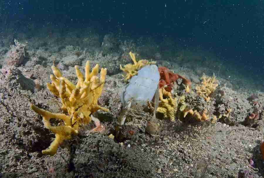
Sublittoral rock indicator: spatial correlation between environmental conditions and biological data Jan 1, 2017 - Jun 1, 2018
The Joint Nature Conservation Committee (JNCC) wish to develop and calibrate the ‘morphological diversity of sponge assemblages plus anthozoan species composition and abundance’ indicator for the monitoring of sublittoral rock. Initial analysis of So...
Read More about Sublittoral rock indicator: spatial correlation between environmental conditions and biological data.
CoCoast - New ‘Marine Evidence’ proposal, Big Sea Survey 2 Jun 23, 2015 - Oct 31, 2018
Yorkshire Coast Shark & Ray Programme ENG3021 Jun 1, 2019 - Dec 31, 2020
This project aims to support the monitoring of a series of protected and commercial shark and ray species assessing their distribution, site fidelity and movement on the Yorkshire Coast. The project intends to facilitate a citizen science led program...
Read More about Yorkshire Coast Shark & Ray Programme ENG3021.
Coastal ecological enhancement in the Humber Aug 1, 2020 - Jul 31, 2021
The sea-surface temperature of the UK waters has risen by 0.5-1.0 °C since 1870 and, during the twentieth century, both mean and extreme sea level have risen by 14cm (UKMMASS, 2010). The resulting sea level rise has reduced the area of the intertidal...
Read More about Coastal ecological enhancement in the Humber.
About Repository@Hull
Administrator e-mail: repository@hull.ac.uk
This application uses the following open-source libraries:
Apache License Version 2.0 (http://www.apache.org/licenses/)
Apache License Version 2.0 (http://www.apache.org/licenses/)
SIL OFL 1.1 (http://scripts.sil.org/OFL)
MIT License (http://opensource.org/licenses/mit-license.html)
CC BY 3.0 ( http://creativecommons.org/licenses/by/3.0/)
Powered by Worktribe © 2025
Advanced Search