
Dr Magnus Johnson M.Johnson@hull.ac.uk
Senior Lecturer in Environmental Marine Science

Research Repository
Dr Magnus Johnson M.Johnson@hull.ac.uk
Senior Lecturer in Environmental Marine Science
Dr Ralf Bublitz
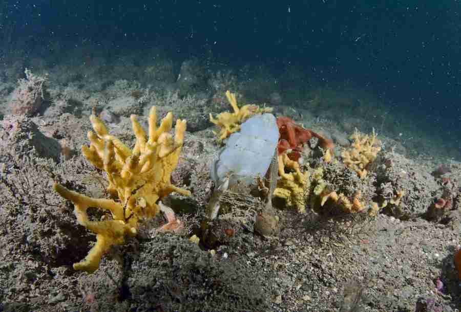
This project aims to accurately map the distribution of nearshore features within the Holderness Inshore MCZ, Flamborough SAC and Runswick Bay MCZ over 17,300m of transects.
This project will pilot the application of newly enhanced oil & gas inspection technology which has now been scaled down to a sufficient size for deployment by a single operator, with longterm duration battery and upgraded to provide submersible operation to 30m. The University proposes to utilise this enhanced functionality to address significant data deficiencies in 3 Marine Protected Areas (MPAs) within the Yorkshire Coast.
| Type of Project | Small Grant |
|---|---|
| Project Acronym | Benthic Crawler |
| Status | Project Complete |
| Funder(s) | Marine Management Organisation |
| Value | £57,387.00 |
| Project Dates | May 1, 2018 - Mar 31, 2020 |
Sublittoral rock indicator: spatial correlation between environmental conditions and biological data Jan 1, 2017 - Jun 1, 2018
The Joint Nature Conservation Committee (JNCC) wish to develop and calibrate the ‘morphological diversity of sponge assemblages plus anthozoan species composition and abundance’ indicator for the monitoring of sublittoral rock. Initial analysis of So...
Read More about Sublittoral rock indicator: spatial correlation between environmental conditions and biological data.
Humber Aquaculture Partnership - Project 1 Sep 1, 2018 - Sep 30, 2020
Partnership with YWT to develop an aquaculture site on Spurn Point.
Humber Aquaculture Partnership - Project 2 Sep 1, 2018 - Sep 30, 2020
Part two of the Humber Aquaculture Partnership
Humber Aquaculture Partnership - Project 3 Sep 1, 2018 - Sep 30, 2020
Development of educational and research aquaculture facility on Spurn Point
Yorkshire Coast Shark & Ray Programme ENG3021 Jun 1, 2019 - Dec 31, 2020
This project aims to support the monitoring of a series of protected and commercial shark and ray species assessing their distribution, site fidelity and movement on the Yorkshire Coast. The project intends to facilitate a citizen science led program...
Read More about Yorkshire Coast Shark & Ray Programme ENG3021.
About Repository@Hull
Administrator e-mail: repository@hull.ac.uk
This application uses the following open-source libraries:
Apache License Version 2.0 (http://www.apache.org/licenses/)
Apache License Version 2.0 (http://www.apache.org/licenses/)
SIL OFL 1.1 (http://scripts.sil.org/OFL)
MIT License (http://opensource.org/licenses/mit-license.html)
CC BY 3.0 ( http://creativecommons.org/licenses/by/3.0/)
Powered by Worktribe © 2025
Advanced Search